22 Aug Bessans to Refuge Le Montana via Refuge du Plan du Lac – D15 & D16 (FW D2 & D3)
Fun Week Day 2 – Bessans to Refuge du Plan du Lac
Just to clear up a point of confusion in the title. Today was such an awesome day that we can’t possibly continue calling this week Hell Week. It’s now become Fun Week, an altogether more positive way of looking at things. Moreover, today I had enormous fun turning what looked like a grind of a day into attempting to slice off as much of Dillon’s time for the hike as possible. It was me against Dillon.

The gauntlet was inadvertently thrown down by Geoffrey in an indirect way at breakfast. Richard had mentioned that we’d been beating Dillon’s times to the top of cols etc., which Geoffrey qualified by saying that overall during the day we’d been slower than Dillon’s timings. Richard replied that Dillon’s timings are walking times and do not factor in stopping for drink, coffee, lunch or messing about in rivers trying to ford them safely. If we took all that out we’d be sub Dillon’s times.

There was only one way to find out – do the whole of today’s walk without stopping. No one directly said we’d do that, but it was definitely in my mind to see how quickly I could cover the 30km from Bessans to the Refuge du Plan du Lac. According to Dillon’s Hiking The GR5 by Cicerone the distance is 30kms and should take 9h 15m:


Unlike every other start we’ve had on the GR5 this one began with almost 4.5km sauntering along on the flat following the course of the river. All very genteel and chummy. Normally conversation dries up entirely once we’re going seriously uphill. But on this occasion we ambled along. The madness of taking on Dillon’s timings hadn’t really occurred to us.

All that changed when we got to a charming little rustic village Le Collet and the GR5 turned very steeply to the right and just kept zig-zagging on and up for over 500m of ascent.


I’d got completely into a hill-climbing zone. I try to get it over as quickly as possible. In that state I steadily left Richard and Geoffrey behind and overtook groups of hikers and their guides. By the time I’d got to the point where the climbing stopped I was quite alone. The path levelled out and became what is known as a balcon or balcony which, with a few undulations, pretty much stuck to the same contour line. I guess it was at this point I decided to see how much of Dillon’s timings I could cleave off.
So, I started running with all that gear on my back. Running on the flat and downhill and tabbing fast on the uphill. These are all techniques that are taught to recruits in the Parachute Regiment. Tabbing is the Parachute Regiment’s equivalent to what the Royal Marines call yomping, but much, much faster.
The term TAB came out of WW2 when British Airborne troops were expected to move as quickly as possible in some sort of formation from the Drop Zone into battle. So the Tactical Advance to Battle entered the Para Regt lexicon.
Over the years tabbing became a refined art. Recruits are expected on P Company test week to complete a 10 mile tab carrying a Bergen weighing 40lbs and a rifle weighing 12lbs in less than two hours. A minute over and it’s an outright fail and the recruit can go and join some other regiment. If you want to get the full 10 points for that event you must complete the test in 1h 45m by coming in with the group led by the PTI who sets a pace that gets that group in at exactly 1h 45m.
This is not an easy thing to do carrying all that gear and sustain 6mph. You can’t do that over broken terrain without learning how to speed march up hills and run down them and along the flat, not like some demented fell runner, but by using a quick shuffling gait that is faster than trotting but not a full running stride, which would be unsustainable, and impossible with that weight.
The key to tabbing was the speed marching – the bit you do when not shuffle-running. The rule of thumb is you speed march up hills, you shuffle-run down them and you combine the two techniques on the flat, alternating between them to use different muscles. The speed marching took some learning. The posture is not normal and the necessary muscles are untrained and have to be developed. Essentially, you lean forward at the waist, stick your arse up, head down and kind of waddle your hips with with each stride – an exaggerated hip movement that significantly increases your gait. Once you get into the swing of it you can eat up terrain tremendously quickly.
Parachute Regiment recruits get this thrown at them from day one. By week five of basic recruit training they are tabbing up and down Pen Y Fan in the Brecon Beacons at breakneck speed. The test is known as the Fan Dance and was adopted buy the SAS as one of the early filtering tests to get rid off all those who never going to make it physically. But with them, they’re testing grown up mature soldiers who have years of experience behind them. Now there’s an enterprising bunch flogging (literally for money) the Fan Dance experience to civilians who are looking to do something that is quasi military. It’s wrapped up as an ultimate experience, but in reality teenagers in Para Regt with only five weeks in the army do this routinely. Or, at least, did when the Parachute Regiment was based in Aldershot. But, tabbing and the Fan Dance are really not that big a deal…if you’re in or have served in Airborne Forces in UK.
So, these are the techniques you need to slice into Dillon’s timings and today was the perfect opportunity to turn it on.
Initially, quite a lot of activity was going on up there on the balcony. I ran trough a throng clustered outside a chapel. Clearly, some sort of religious festival was going on. But that was soon behind me. The next surprise was a farmstead where the farmer had personally diverted the route around his farm and had concealed or obscured a GR5 sign. I guess the locals in the hills get pretty fed up with the constant stream of hikers tramping past. The farmhouse door was guarded by a tethered but not very frightening looking dog. It was tethered for a reason, so I didn’t loiter.

At another farmstead, a bothy really, a clear stream of water issued from a well. I’d lost a lot of fluid on the way up in the baking sun so rather than thrown off the pack and squirt half a litre of water down my throat I used a clever little rubber cup I’d bought in Val d’Isere. It collapses into nothing and can be carried in a pocket yet springs to life once released. It’s perfect for drinking from water sources on the hoof. In fact, it’s proved so useful I’d say it’s probably the second most useful item I have, after the Merino wool top.

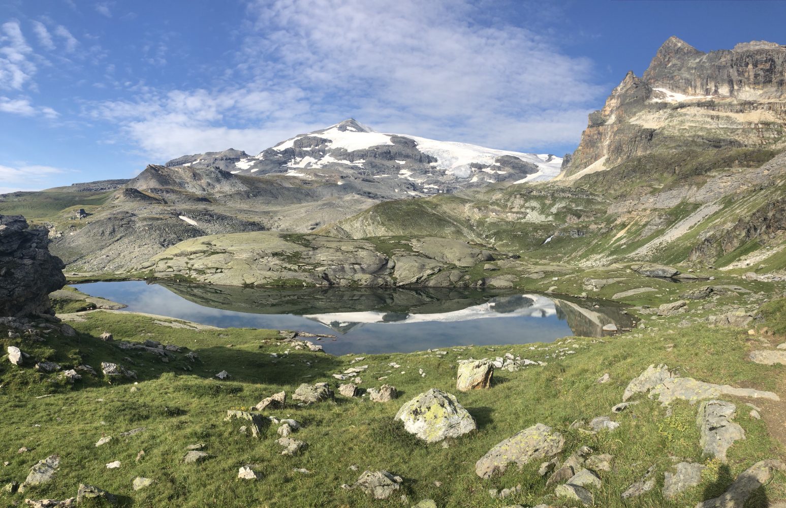
Occasionally, the track lost height at re-entrants, cut through by rivers, and so the track would drop to the river, cross via some timbers thrown across and gain height back up the other side. And so on until I reached the Refuge de Cuchet where Lego Tatiana did some posing with the valley floor providing a stunning backdrop. I think I’d taken just over three hours to reach the Refuge at 11.45am. The sign there said that the Refuge du Plan du Lac was 4h 40m away. If that was true then I might just break 8 hours for the whole. But, the aim was to get under 7 hours, which seemed doable with some (a lot of effort).

From the Refuge de Cuchet, which I left at exactly midday the track widened into a proper sized road all runnable downhill – fast. After 40 mins of shuffling downhill at a decent pace I came to a junction where the GR5 once more bore right and up. All that lost height had to be painfully gained. I picked up a voicemail form Richard to say that they’d just left the Refuge de Chuchet, which put them about 40mins behind me.

At this point the GR5 swings maddeningly north. For the past two weeks we’d been steadily working our way south-ish towards the Med. But now, inexplicably the GR5 takes an incomprehensible detour north for about 12km up one side of a very broad valley only to come back down the far side heading south. Completely pointless and counter-intuitive. These two long 30km back-to-back days were all about ‘exploring’ this valley and not getting too much further south than we had been at Bessans. So, all this effort of ours was being expended going in the wrong direction.

Worse still, this was the second major ascent of the day coming at about the 20km point – steep and winding and nowhere where you could actually do some tabbing. You had to just plod on up and resist the temptation to stop and admire the view. The track went over this bloody great lump of rock that was initially wooded with pine, where occasionally it was blocked by tree-fall.

Once the tree line fell away the track continued up and eventually over this bare-arsed feature whereupon a panoramic view of a very large valley system through with ran le Doron de Termignon river. In the far distance I could make out the Refuge du Plan du Lac. Even with the winding nature of the GR5, clinging to the east wall of the valley, I couldn’t quite see how we were going to screw another 10km out of this terrain. It looked more like 7km or at best 8km. This was going to be a Dillon overestimation. Not 30km, but somewhere between that and 25km.

Dark clouds were gathering in the mountains to the north and I really wanted to beat the rain, so I set off having guzzled more water and some nuts and raisins. I was reasonably fatigued by this stage so was grateful when the last five or so kilometres were all downhill and gravity could do the job.
A couple of kilometres south of the refuge is a large car park. It was full of coaches and day trippers hiking about for the day before being bussed down to the valley. From the car park the GR5 cuts north to the Refuge du Plan du Lac through Bonjour alley. I’d spent virtually the whole day in splendid isolation high up on the balcony routes where there wasn’t much need to say bonjour. But here in Bonjour alley I came head to head with scores and scores of day trippers all heading back to the car park and all of whom required the obligatory bonjour as I ran past. I got a few of those ‘you’re demented looks’ and mothers tried to protect their children as I tabbed and shuffled past, determined to beat 7 hours.

I literally ran into the Refuge and stopped the clock. 27.29km, 6h 48m total time, 6h 39m moving time. That smashed 26.5% off Dillon’s 9h 15m. And I’d beaten the rain.
I found our room, showered, changed, washed my gear, prepped my bed, sorted out Richard’s and Geoffrey’s arrival. Then the rain came down. An hour and fifteen minutes later Richard and Geoffrey arrived, pleased that they too had taken an hour off Dillon’s timings. And they’d made a couple of stops for water and tea. So, a good result all night.

The Refuge du Plan du Lac is very friendly and welcoming and evidently popular judging by the occupancy, many of whole were day trippers and not hikers. The communal evening meal was again three courses: a hunk of cheese and unnamable soup, an amazing lasagne and cake. I had four helpings of lasagna – high on the gluttony scale. But, I knew what’s coming tomorrow.
Tomorrow’s hike is said by Dillon to be 31kms in the opposite direction and tricky enough to take 10 hours. After a quick discussion with Richard and Geoffrey it was decided that rather than bumble into an assault on the overall time, it should be attacked head on from the first step. So, I’ll be setting out on my own. Geoffrey’s a statistical mathematician and we’ve sort of agreed that the 26.5% has to be beaten and he reckons ‘at least 30%’ off. What fun!
Fun Week Day 3 – Refuge du Plan du Lac to Refuge Le Montana
Bright-eyed, bushy-tailed, barnacle-breasted, fully booted and spurred, ready to go! That was me this morning at 7.45am. under a cloudless sky. Another hottie.

Slept really well in our bunk bed accommodation. After a 7am breakfast of cereals, bread and jam (nothing gets cooked in France for breakfast, bar the odd hard boiled egg – no concept of a full fry up) and coffee or tea.
Richard was aghast, ‘I can’t believe that a country that has given the world so much civilisation still insists on drinking coffee out of bowls.’ He has a point – no handles, it cools quickly, what’s the point?
But, today was race against Dillon’s clock day. I felt quite confident with a belly full of lasagne. The route was challenging, though. Dillon has it as 31km to Refuge Le Montana in Hiking The GR5 by Cicerone. I thought I’d add what he has to say about it in brief.


Take a look at how he displays the ascent and descent profile. It misleads you somewhat into thinking that there isn’t much in the way of ascent and descent. At the end of this piece I’ll provide you with much more realistic profiles of what the ground is really like.
In blissful ignorance of this I ran off on my own, Richard having fired the metaphorical starter’s pistol. The first two or three kilometres were all downhill on a stable track. I could see a group of early morning hikers about two-thirds of the way down. By the time I’d run to the bottom I had an impressive average speed of 4.7km per hour. If I was going to lop 30% off Dillon’s estimated time, I’d need to keep that figure no lower than 4.1kmh. Anything less than 4.0kmh and I’d be over 7 hours. I was looking to chop three hours off his 10.
At the bottom was a fast flowing river. My first mistake was to cross it using the first bridge that came into view. This error cost me a few minutes and the group of youngsters, three men and two women all in their 20s got ahead. But, they were unable to locate the zig-zag path that took us from river level up to over 2,500m. So, I took the lead. But, the lead pair quickly caught me. They were fit. Eventually, one of the girls also sailed past me effortlessly. I don’t know what they had in their packs but they looked fairly hefty. Kudos to them. I found myself sandwiched between the fittest and the tail-end-Charlies.

But as David Mamet noted, old age and treachery will always beat youth and exuberance. I’d seen the lead guy smoking roll up after roll up the previous evening and knew that even youthful lungs full of tar would eventually tire above 2,500m. As I crested the high ground I saw that they’d stopped and discarded their packs. Big mistake. I started running down the track and basically didn’t stop until I got to a gushing river a couple of kilometres further on to use my magic little collapsible cup. I took on at least a litre and still had two on my back. At one stage I vaguely saw them in the distance but they were way too far back. I never saw them again.
In fact, I saw almost no one again. I was tabbing along in splendid isolation surrounded by moraine fields, high glaciers and jagged pikes, one of which was called Mount Para! I passed foaming river after river, all passable with good wooden bridges. Inevitably there was always some uphill after each river to recover the median balcony height that contoured around this high and spectacularly isolated landscape.

The sign at Refuge du Plan du Lac read that the Refuge de l’Arpont, about a third of the way down range, would take 4h and 40m. I got there in 3h dead with a healthy average of 4.6kmh on the clock. I thought that the worst of the climbing had been at the beginning, based on Dillon’s graphic and a brief map recce (very brief – I really hadn’t studied the ground in any great detail and trusted Dillon to deliver an undulating profile – I’ll never make that mistake again!)


I stayed at the Refuge de l’Arpont just long enough to suck down a half litre of water with some rehydration salts in it and to remove some small stones from my boots before taking off down hill so fast that I hoped to turn the average into 4.8kmh or even higher.


But then disaster struck. At the bottom of this long downhill run was a boggy meadow a ruin and two horses. I followed the track to the ruins to better photograph the horses and proceeded in what I thought was a logical direction. In reality the track had actually taken a right (not obvious at all). The further I went towards the sound of roaring water the more the track began to disappear. A check of the map showed that I’d trapped myself having lost height against a river I couldn’t possibly cross. Two options: backtrack and lose considerable time or go directly towards the track. I chose the latter, which involved a free climb up bare-arsed precipitous rocks. Having wasted the best part of 30 mins and a huge amount of energy I gained the track. My average had dropped to 4.2kmh. I couldn’t afford to lose much more.

Unfortunately, the track started a steep unanticipated ascent that seemed to go on and on. I was almost on my chinstrap and the possibility of getting this done in under seven hours seemed at that moment quite remote.
One climb gave way to a little downhill and then yet another hideous ascent. In fact the last third of this ordeal seemed to be more up than down. But, there were opportunities to pick up speed and run. Anything vaguely downhill or flat I ran. Eventually, the path took a decidedly steep zig-zag. I didn’t bother with that and simply took a straight line downhill. My average crept up to 4.1 and then 4.2 as the track skirted round impressive scree and horse shoes.

I was pretty much hanging out. Feet were quite bruised from being bashed about on the uneven rocks that passed for a track. Just when I thought there could be no more uphill, I’d turn a corner and up it would go, ‘Oh for [expletive]’s sake! Not more! When will this end?’
Eventually it did. I passed a sign that claimed that the Refuge Le Montana was 30 mins away. It was 6h 21m on the clock. If I kept running I reckoned I’d make it. I stopped to guzzle some water from a small waterfall just as three female hikers were doing the same. They gave me curious looks. My shorts were soaked with sweat and it looked like I’d pissed myself. My shirt was essentially salt-encrusted and I think I had snot streaming from my nose, and was probably frothing at the mouth as well.

And off I went again in pursuit of time. By this stage I knew I’d probably manage it. The Refuge Le Montana, which is at the top of a chair lift from the valley below. I ran in just as rain clouds were forming. Once again I’d beaten the rain and the clock. 6h 45m, of which 5h 50m was moving time. The former represents almost a third off Dillon’s time. But, I was shot!
Richard and Geoffrey cruised in two hours later having comfortably beaten the 10 hours by 90 minutes. But they had stopped and bought tea and enjoyed the views from the Refuge de l’Arpont, so in effect their moving time was about 7h 30mins at a more sedate pace.
Obviously, what I did was not hiking in any sense of the word at all. What Richard and Geoffrey did was, and still for men in their mid 60s they cruised in quite comfortably.
But on one thing we were all agreed. The way height over distance is diagrammatically displayed can have a profound impact on managing expectations.

Here’s what the profile looks like in Strava:

And here’s what it looks like in Garmin:


The only thing I don’t believe about the statistics above are the calories I burned.
‘I’m so hungry I could eat a bloody horse!’
‘Don’t say that too loudly in France.’
Stay tuned!
Vital Statistics:
Bessans to Refuge du Plan du Lac:
https://connect.garmin.com/modern/activity/2950148716
Refuge du Plan du Lac to Le Montana:
https://connect.garmin.com/modern/activity/2950791705