01 Sep Ceillac to Larche via Maljasset – D25 & D26
Ceillac to Maljasset, Day 25
Today was the best start to any day we’ve had so far. Why? Because Godfrey had kindly brought over some Marmite and today’s breakfast was the first in France when I could use Britain’s empire-building version of Kryptonite on my toast instead of the usual jam. Lego Tatiana was thrilled as well. I think she’s also got pretty fed up with the runny jam too. I’d had this problem in Russia and had been saved by Tim Moffatt, the BBC’s deputy head of High Risk, bringing me out two jars of Marmite.

Marmite is such a key determinant of Britishness that it should be part of the immigration citizenship test. Would-be Brits should be placed in a room where samples of Marmite and jam are on offer – labelled Substance A and Substance B. They must eat both. They are then instructed to proceed through either door A or B according to which they preferred. Needless to say, the door for the non-Marmite product takes them back overseas.
The Marmite was doubly appreciated because we’d hung one on a little bit last night. Godfrey and Phil had arrived in a blacked out Mercedes, the sort that Russian mobsters liked to not be seen in around Moscow in the 1990s. They arrived just as Richard, Desiree and I were eating. It was Desiree’s birthday so she and I drank two bottles of white wine. The most alcohol I’d had on this trip.
This morning as we tucked into breakfast she was nowhere to be seen. We feared such a dreadful hangover that we may have critically dented her very tight itinerary to Nice. But, she’s made of sterner stuff than that and surfaced just as we were finishing up and lacing up boots.

Before setting off we posed for a Fools photo in front of Richard’s ancestor – a hero of the valley and local hiking. L-R Phil Neame, self, Godfrey McFall and Richard Villar.
And then, as a group of four, off we set for a 13 day adventure. Godfrey and Phil were lucky. As with the route out of Bessans there was no immediate ascent. We paralleled the river for a couple of kilometres heading up the valley towards the Col de Girardin (2699m) – the highest to date. Today’s route is best described by Paddy Dillon’s graphics from Trekking the GR5 by Cicerone:


As we warmed up walking briskly along the river the air was cool. I dreaded the sun today. My face still hasn’t recovered from a searing a few days earlier and even though I’d slathered UV protection all over it I wasn’t looking forward to more radiation beating down. I wondered whether a few days of rain wouldn’t make a nice change.

The nice early morning stroll didn’t last long. Inevitably the path hooked right and began a series of steep switchbacks through he woods as we steadily gained altitude. I pulled away from the rest as I wanted to get the ascent part over with as quickly as possible. Soon sweat was pouring off me and running the UV cream into my eyes, partially blinding me. I staggered and lurched on up until the trail which flattened out to the first of two lakes – Le Lac du Mirroire, which fully lived up to its name. It reflected beautifully the surrounding mountains and was one of those jaw-dropping places where you definitely pitch your tent if wild camping. In fact, someone had.

I pushed on as we’d agreed loosely that we’d meet for a brew at the higher of the two lakes, the Le Lac de St. Ana, so named because there’s a chapel at the lake to said named saint. And that’s where we met up and indulged in the first of the Fools’ rituals – brew making. Godfrey has a Jetboil. Phil doesn’t. He’ll drink brews made by others but he doesn’t burden himself with additional gear. His pack weighted in at a whopping 6.5kgs, while Godfrey’s is 8.5kgs. Handbags, as Richard and I call them. They’ve perfected minimalism. In Phil’s case this also means drinking other peoples’ brews.

Brew stop over, we pushed on up to the Col a couple of hundred metres above us. We reached it 3 hrs and 20 mins after leaving Ceillac some 9 kms back. We’d warned Godfrey and Phil that the posted timings and distances should be taken with a pinch of salt and that we’d lop at least an hour off. The stated time had been 4 hours 40 mins so we’d taken off more than an hour without even trying.
In fact, we were making such good time that if we didn’t stop on the Col for another brew we’d be in danger of arriving in Maljasset 5km hence in the valley below – far below, and very, steeply far below – in time for lunch. Yet again the 17km distance looked like it was going to be more like 13km. Just as we were preparing to go our slightly separate ways, who should come tabbing up to the Col? Desiree, of course! Looking very cheerful. But sadly, she was too late for tea.
Phil, Godfrey and Richard decided to stick to the GR5 and began their steep descent. But, there was an enticingly high mountain just to our east that promised a good climb up and possibly a transit down to the next col along, through which ran another track to Maljasset. So, off I set up this thing and was rewarded with tremendously spectacular views all the way back to Mont Blanc where we’d been two weeks previously. Looking back over the Ceillac valley over one range of jagged peaks after another all the way back to Mont Blanc was quite sobering and a good indication of the terrain that Richard and I had crossed.

But, I was not to be rewarded with an alternative route to Maljasset. The ridge line climbed higher to a triangulation point and ended abruptly with precipitous drops on three sides. I turned back and backtracked all the way down the Col and descended the hellishly steep route that the other three had taken, arriving at the Aubege de la Cure a little more than an hour after them. The views from the top had been worth the extra effort.

Curiously, on the way down, for the second time, I passed mountain bikers pushing their bikes uphill. It seems such a completely pointless activity.
Maljasset to Larche, Day 26
Today was the day I nearly got eaten by a sheep dog that was as large and as ferocious as a lion. And I was entirely on my own when it happened.
The Maljasset to Larch route is slightly contentious in that the first seven kilometres down the valley is essentially on a tarmac road that follows a river. All this can best be seen in Paddy Dillon’s graphics for the day from Trekking the GR5 by Cicerone. In it he suggests that hikers avoid the tedium of walking down a road by jumping into taxis. From the outset Richard and I had said that we would walk the road. Pride simply wouldn’t allow us to concede that we hadn’t walked the whole GR5/52. Godfrey and Phil were set to get a lift down the valley while Richard would go off on foot.


But, if you’re prepared to abandon being a GR5 stickler and if you’re keen to avoid a tramp down a road, there is an alternative slightly harder option to Larch that leaves Maljasset and strikes due south through a valley climbing to a series of impressively high Cols and one peak at just over 3,000m…in Italy. The route in fact spends most of the day in Italy before tracking back into France.
In the interests of avoiding walking down a road I chose the Italian option. The couple running the Auberge had good local knowledge and said that the route was doable, but very up and down, would require a light pack only and would take between nine and ten hours. The husband stressed that it was easy to get lost in Italy and that map reading had to be good.
So, we agreed to go our separate ways for the day. Phil and Godfrey had abandoned the vehicle plan and would keep Richard company on the road, while I’d set off south to explore this difficult route. These would be the highest cols of the whole trip. We were up at 5.45am and ready to go by 6.45am. We had an agreement to leave a sign at the Col du Vallonet, through which I would have to pass as I re-entered France from the direction of the Roche Blanche to the east. Mobile phone communications couldn’t be relied on so we agreed to mark up the signpost at the Col du Vallonet such that whichever party arrived later would know that the other had already passed through and not to waste time waiting. It was highly unlikely that I’d get there first because the distance and going were to be very challenging.

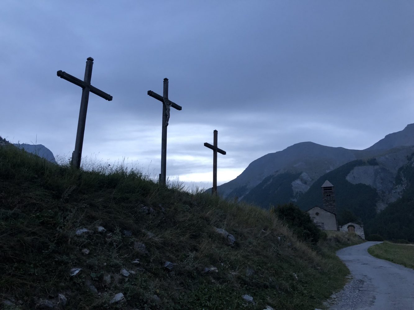
I left Maljasset passing under three huge crosses, reminding me that that my fate was not really in my hands. I hardly thought that the most dangerous event that day would be coming face to face with the fiercest sheep dog I have ever seen. And it had every intention of going for me. I’d spent a happy hour gaining height through a forested valley towards the Col de la Traverse when I spotted a cottage with smoke drifting from the chimney. Beyond that were several hundred sheep corralled in a fenced off area. I gave them a very wide berth. But, as I walked along the track from around the corner came a huge lean dog with a leather collar that was covered in spikes and curved metal hooks. This was no Fido. It started growling and barking and I immediately guessed it was a guard dog of some sort. As it lunged at me I lowered my hiking poles. If it really went for me I’d ensure I’d shove one of the poles as far down it’s throat as it would go and use the other to stab its eyes. But, before that came to pass, a shepherdess at the cottage started screaming at the dog, presumably ordering to leave me alone. That was enough to put it in two minds. So instead of attacking it shadowed me while the woman kept shrieking at the animal. Eventually, I put enough distance between myself and the sheep for this beast to lose interest in me.


The auberge owner had been entirely correct about this route. It was extremely challenging largely because the mountains were high and jagged, and the approaches to the cols were so steep as to appear almost vertical. And they came in series, like a giant rollercoaster ride. The first was easily gained and took me to the top of Monte Ciaslaras (3011m) from which the views into Italy and back from where Richard and I had come were stupendous.


But the descent was shockingly steep on loose shale. Negotiating this couldn’t be hurried and required poles and much clenching of muscles and teeth.

And just as I’d managed to drop back down into a valley floor there’d be another one and up and over I’d go. And so on. One of the cols was so steep that the Italians had kindly fixed ropes and steel cables to help people haul themselves up.

The tracks on the map were more aspirational than real and in the end I gave up trying to match my route to an imaginary track on a map. I just headed for the next col over the rough terrain, sometimes slithering over scree slopes to lose height and traverse in roughly the right direction. Along with tracks there was also an absence of human beings. I saw not a soul until I ‘popped’ over the Col du Stoppia back into France and dropped down to the rendezvous point at the Col du Vallonet, where I found the others’ note. They’d passed through the Col at 1200 and I hit it at 1340. I hadn’t really stopped moving since leaving the auberge seven hours previously.

And I didn’t stop at the Col du Vallonet either as Larch was still another nine kilometres away. So, I just keep moving and only stopped after climbing the last col above a spookily abandoned fort.

Before dropping down to Larch some 4.5kms below in the valley I needed to empty some stones out of my boots, drink a litre of water and have some of Geoffrey Grimmett’s sausage. By the time I got to Larch and found the auberge exactly 9h and 14m had elapsed since leaving Maljasset. The auberge owner had been right – somewhere between nine and ten hours…with a light pack!
But the views had been spectacular. I’d enjoyed the solitude immensely. In those nine hours and fourteen minutes I’d covered just over 27kms, climbed over 1,900m and descended over 2,000m. The Strava profile says it all:

The blue trace is my route from Maljasset to Larche.

Stay tuned!
Vital Statistics;
Ceillac to Maljasset: https://connect.garmin.com/modern/activity/2977210046
Maljasset to Larche: https://connect.garmin.com/modern/activity/2977244698