20 Aug Val d’Isère to Bessans – D14 (HW D1)
Hell Week Day 1 – Val d’Isere to Bessans
Wet boots, socks and feet.
Today is the first of seven in this third phase of Tatiana’s Gambol which we’re calling Hell Week on account of the rather long cumulative distance that we have to cover between Val D’Isere (VD’I) and Briançon – 168km and some 8000m of ascent.
As you’ll have gathered from the previous blog, we’re joined by Geoffrey Grimmett, the outgoing Master of Downing College, Cambridge.
There’s one thing that sticks in my mind about the Hotel Bellier in VD’I, namely that Bilbo Baggins would have loved it. When I first saw my room I thought there had been a mistake.
‘You’ve given me a room with a child’s bed.’ I told the receptionist.
She checked the room number and said, ‘No. That’s a standard single.’ And then quoted measurements in centimetres. ‘And all our single beds are that size.’
‘Well, Hobbits would find them roomy but humans maybe not.’ She looked at me in a puzzled way, probably because she didn’t know what a Hobbit is.
So, if you’re going to VD’I and are over 3′ tall, avoid the Hotel Bellier. But, that’s First World problem, I know.

So, we mustered at 8am outside the Bellier and off we set for the Col de l’Iseran and ‘just round the corner’ to Bessans about 25kms distant. On the map it all looked pretty straightforward. All the hard climbing at the start then downhill all the way…almost. We set off in good cheer. Not a cloud in the sky. It was going to be another scorcher.

I was quite glad to be leaving VD’I and so was Lego Tatiana. Unless you are a skier and it’s the skiing season, it’s a bit of a one-horse town tourist trap: Main Street, bars, cafes, some restaurants, some okayish outdoorsey shops (nothing like Chamonix) and everything hellishly expensive. One beer €10 – ouch! It was great to have had a rest and replenish the fuel tanks, but VD’I left me feeling as flat as Tignes, another tumbleweedy type place. I’m looking forward to our two days off in Briançon, which has historical charm and interest. But first we have to get through Hell Week.

When you’re hiking in the Alps you end up going up something steep and sustained within about 10 minutes of leaving your lodgings. VD’I is no exception. The ascent to the Col de l’Iseran is 950m (3,163′ – Scarfell Pike is less). But, it’s still steep and heavily wooded initially with some large swathes chopped through for skiers.

Within 30mins we spotted another hiker slogging up one of these tree-lined ski runs. As I gained on her (bright pink top) she turned as she heard me.
‘OMG! Steph! Fancy meeting your here!’ It was our German friend from La Chapelle d’Abondance, the one who was wild camping her way down to Menton. Richard caught up and they greeted each other like long lost friends. We introduced her to Geoffrey. I wondered if the Ninja of the Alps was lurking somewhere nearby and would spring out of the trees, Cato-like.

Geoffrey and I left Richard and Steph to natter and off we set at a good old uphill pace. Geoffrey is very tall, has a long gait and is not weighed down with the same kit Richard and I are carrying. But, he’s fast, particularly downhill. He’ll shoot off as if late for a meeting in Cambridge. Very energetic.


After two hours and sixteen minutes we hit the Col de L’Iseran (2,770m). By now we’d left the tree line behind and the going was open – more shrieking marmots scampering and ambushing. But, the col itself is disappointing. A road, the highest in France, runs through it. There’s a car park at the top and a big building, a chapel and scores of people hanging out on their motorbikes, bicycles and cars. Geoffrey got talking to some Brit fellow who drives his Morgan all round Europe.


It was a bit like Piccadilly Circus – a meeting place for petrol heads and cyclists. Col de L’Iseran was the highest we’d walked to and the ugliest. But the height offered stunning views of remote mountains and glaciers to the south – where we were going. Paddy Dillon’s graphics from Hiking The GR5 by Cicerone give you an idea of today’s route:


From the Col we had an equally steep, knee-jarring descent down a steep and rocky track, past a crossing point at Pont de la Neige which had been washed away and then on down a precipitously narrow gorge – precipitous and high enough for them to have put up fixed equipment. The descent ended at La Lenta where a variant of the Route called the GR5E takes a less arduous flat route to Bessans along the valley floor. E for easy, I guess.

Astonishingly, Geoffrey proved to be something of a speed merchant downhill. No sooner had we set off from the col than he disappeared like a Fell runner. What’s the hurry? But it dawned on me that Richard and I had naturally found a convenient energy-conserving pace that would get us through the day and the whole journey. We’d gone a bit Zen in the walking, which in itself can be a narcotic experience.
At La Lenta we stuck with the GR5, little realising that it involved a very serious gain in height. We struggled up to altitude again, but it was worth it. Although the signage was non-existent, Gaia GPS put us straight into the high level ‘balcony’ route that climbed and contoured high on the right of the valley with a drop of several thousand feet. In places the track was no better than sheep track and you began to wonder if you were even on the GR5. The GR5E runs through the valley in the image below:

High above us waterfalls crashed over cliffs and frothing rivers cut down across the route. Most were passable, but inevitably, as we were more than halfway along the escarpment and totally committed to getting to Bessans that way, we came across a raging, foaming, roaring river which was so fast it had washed away any evidence of a crossing point. We hunted up and down for the least dangerous place to cross. I found somewhere further up, but it still involved a soaking from the kneed down. As I got across I noticed Geoffrey had found somewhere further down but just high enough above where the water shot over the edge to be less risky. He helped Richard and his precious office across.

We stopped to empty our boots of water and wring out socks before proceeding. Just then we saw a waterproofed note warning hikers not to cross the river. But there’d been no such warning on the other side as we’d come upon the river from the opposite direction. We knew we’d been quite lucky. Had it rained today and in previous days we would not have got across and been facing a serious re-think about how to get to Bessans.

A couple of miles further on we found an abandoned bothy at Les Roches and decided to fire up the Jetboil and get a brew going. It was a hot day and lazing about on the grass drying our gear and enjoying splendid views was definitely not a bad way to spend half an hour. We heard a very loud cry of Bon jour and wondered how hikers had snuck up on us. Perhaps it was the Ninja. Alas no! A huge tandem paraglider buzzed us overhead and then turned out into the valley.

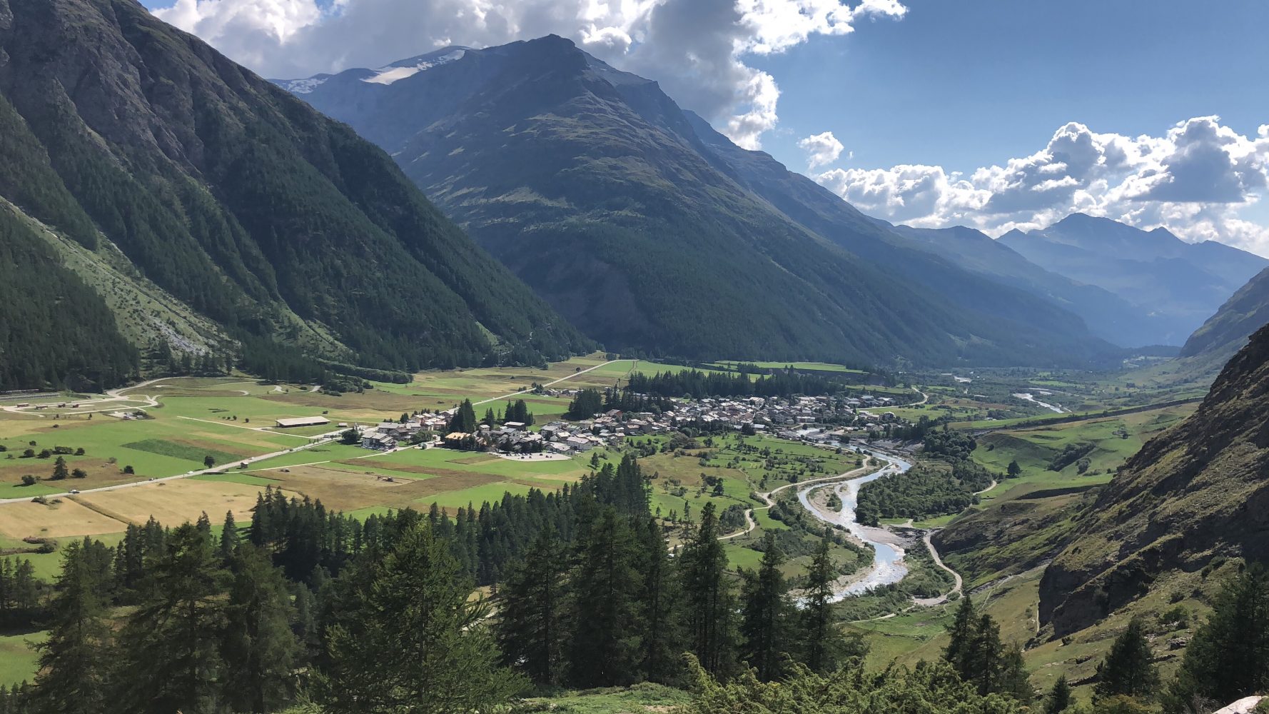
From the bothy we dropped down to a bridge at Le Vallon, where cows grazed and their bells clanged endlessly (how are they are not driven mad by this?), and we then hiked up and over a shoulder that led to our final steep descent to the river at Bessans. As it was all downhill I ran most of it to see how my tendon would hold up. Not bad. By the time I got to a fork in the road, where the GR5 deviates off the main track I was a good half hour ahead. So, I stopped and waited and took off my boots and socks and dried them in the sun and wind. The view of Bessans sitting in its broad flat valley surrounded by incredible mountains and glaciers was stunning.

Half an hour turned into forty minutes and no sign of Richard or Godfrey. So I rang Richard only to discover that they’d taken a slightly different route down and were now tracking along this side of the river somewhere below me. So, I dressed and ran down to meet them. From my high observation point I could actually see the hostel Le Petite Bonheur – our destination for the night.
A straight line between two points is usually the quickest route. Rather than walk all the way up the river to cross it by bridge only to come all the way back seemed silly and a waste of time. For the second time we elected to ford the river. This time I took my boots off. It paid off. Within ten minutes we’d walked a rather eyebrow raising straight line almost through peoples’ gardens, thanks to Gaia GPS, directly to the door of Le Petite Bonheur, where the beds are human and not Hobbit sized.

Tomorrow is day two of Hell Week and the first of our back-to-back 30km routes. We’re in a refuge on Monday evening so there may or may not be a signal.
25km down. 143km to go.
Stay tuned!
Today’s Vital Statistics:
https://connect.garmin.com/modern/activity/2946001450